Saturday, April 28, 2012

Burlington - Sessions Woods WMA

Date Hiked:  Friday, April 27, 2012
Number in Group:  9
Estimated distance round-trip: 2.6 mile loop, plus spurs to tower and falls
Weather:  55°F, sunny and breezy
Websites: Session Woods Wildlife Management Area, Friends of Sessions Woods

The kids spent a few minutes in the education center before we headed out on the Beaver Pond Trail.  The exhibit space is very nice and I highly recommend a visit.  For more information, check out what Steve Wood has written on his Connecticut Museum Quest website.

The loop trail is wide and well maintained.  (The DEEP closed the trails in January for clean-up after the October storm).  Our first stop was the beaver pond.  There is a boardwalk out to a viewing platform, and while we did not see any beaver, we did see an Eastern Painted Turtle, Northern Water Snake, Red-spotted Newt, and a pair of Canada Geese.  (See the tab at the top of the page for links to wildlife identification guides.)
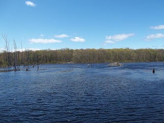
Beaver lodge.


Eastern Painted Turtle.

Northern Water Snake.

Red-spotted Newt.
We continued on the loop trail until we came to the spur for the fire tower.  The tower, which was airlifted into place a number of years ago by an Air National Guard Helicopter (that would have been a sight to see), provides views to the north, east, and south.  Using the profile map provided on the tower, it was easy to identify Rattlesnake Mountain in Farmington.

Looking north.

East with Rattlesnake Mountain visible.
The final stop on our hike was the waterfall along the Negro Hill Brook.  With a pretty mild winter and dry spring, there was not a lot of water, but enough to make it interesting.  The kids enjoyed climbing across the stream and up to the top of the falls on the jumble of boulders.


This was a great hike and I think it would be nice to hike again in the fall.  The autumn colors around the beaver pond and from the fire tower would probably be spectacular.

Wednesday, April 11, 2012

Bloomfield - Penwood State Park

Date Hiked:  Tuesday, April 10, 2012
Number in Group:  10
Estimated distance round trip:  4.1 miles
Weather:  62°F, a few drops from some clouds, but that was it

Although the Metacomet Trail cuts through the Penwood, we decided to stay on the old paved road for the majority of our hike.  We went north from the parking lot, along Gale Pond, past the picnic area and Shadow Pond, to Lake Louise.  From there, we took a trail - very steep, with stone steps - to the Pinnacle Overlook where we could see down the ridge to the Heublein Tower in Talcott Mountain State Park.  We also had a nice view of the center of Simsbury.  We returned to the parking area using the road that runs along the west side of the park.

We saw quite a few wildflowers along the way including Wild Columbine, Dutchman's Breeches, Early Saxifrage, and Leatherleaf.  Unfortunately, my pictures of them leave much to be desired.

Hawk seen near Gale Pond.
 
Leatherleaf at Lake Louise.

Lake Louise.

Steps up to the Pinnacle.

Heublein Tower to the south.

Simsbury center.

Canton - CLCT Smith Tree Farm Trails

Date Hiked:  Tuesday, April 3, 2012
Number in Group:  18
Estimated distance round trip:  1.7 miles
Weather:  Sunny, 60°F, breezy (canceled previous plans for hike due to high winds)

This hike combined two Canton Land Conservation Trust trails.  Both originate at the Smith Tree Farm on Doyle Road (dirt single-lane road for much of the way).

The first trail we did was the Charlotte Craig Trail which is a loop.  It is only .7 miles and climbs fairly quickly to a lookout where you can see Ratlum Mountain.

The second trail, the Ted Wright Trail, is a linear trail with one end on Doyle Road.  From the tree farm, we walked down the dirt road until we crossed a stream.  The trail turned left into the woods and started to climb pretty quickly.  Our goal was Smith's Lookout.

View from Charlotte Craig Trail.

Stream at start of Ted Wright Trail.

View from Smith's Lookout.

East Granby - Peak Mountain, Metacomet Trail

Date Hiked:  Monday, March 19, 2012
Number in group:  17
Estimated distance round trip:  4 miles
Weather:  New record high for this date, 79°F

The most difficult part of the trail is the initial climb from Newgate Road to the ridge.  The trail is fairly level after that except for a quick scramble up to the viewpoint.  From the first viewpoint, you can see south along the ridge to the Heublein Tower in Talcott Mountain State Park and beyond.  We continued on a little farther to a second viewpoint that gave us a better view of the Old Newgate Prison (anticipated re-opening May 2013, not 2012 as I had thought).  Manitook Mountain in Granby is also visible from the ridge.

(The following pictures were taken on a hike I took on March 10th.)

Looking south toward Talcott Mountain.

Old Newgate Prison is brick building across the road.

Manitook Mountain is nearest ridge.