Saturday, October 27, 2012

West Simsbury - Hedgehog Trail

Date Hiked:  Thursday, October 25, 2012
Number in Group: 4
Estimated distance round-trip: 3 miles
Weather: 60°F and overcast
Resources:  West Mountain Trails Map, SLT Walk Book Western Highlands
Highlights of the trip: Views across Farmington Valley


There were only four of us today, but that was okay because we had other commitments that wouldn't allow for much dilly-dallying.  We parked at The Master's School and took the red trail into the woods from the northeast corner of the parking lot.


Off to our right, we came across this little a-frame with a corner missing.  I have hiked this way before and never seen it, probably because the leaves usually block it from view.  We did not investigate it, so I don't know what it was used for.

No idea.
When we had a choice of the green or red trail, we stayed on red.  The green loops back into the red trail farther on.


Eventually, we came to the overlook.  This has to be one of the best vistas around.  According to the Simsbury Walk Book, on a clear day, you can see Mount Tom to the north.  Far to the left, we could see a rather large hill, but I am guessing it was not Mount Tom.  Could it be Sodom Mountain in Southwick?  I wish I had that PeakFinder app for my iPhone (but first I would need an iPhone).

View north looking at Barndoor Hills and beyond.
Looking east over the Simsbury Bog.
Metacomet Ridge in the distance.


The colors on the sumac were beautiful.
We left the overlook and continued on the red trail down, down, down to the stream where it changes from the Hedgehog to the Cathles Trail.  At the bridge, we left the red trail and headed west on the white trail.

Bridge at junction with white trail.
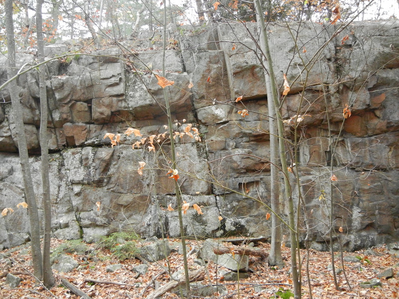
We crossed another bridge and headed south on the blue trail.  The trail is fairly rocky here and I suspect it is pretty wet in the spring.  You can see the talus slope to your left.  One thing I noticed is that the rocks are quite a bit different from the Metacomet.  The traprock on the Metacomet is basalt.  Here, there seemed to be more schist.  Many of the rocks we were walking over had large crystals of quartz and other minerals.  They were really interesting and I wish we had a geologist with us to explain what we were seeing.

Western side talus slope.

Herb Robert (Geranium robertianum)
As we continued south on the blue trail, we could see the Simsbury Reservoir through the trees to our right.  We wound our way along the trail and could see some of the buildings of The Master's School to our left.  After connecting with the red trail again, we eventually returned to the parking lot.

American Beech
A colorful carpet of leaves.
This is a great fall hike with spectacular views of the Farmington Valley.  I highly recommend it.


Thursday, October 18, 2012

East Granby - Cowles Park to Metacomet to Tariffville Gorge

Date Hiked:  Wednesday, October 17, 2012
Number in Group: 8
Estimated distance round-trip: 2+ miles
Weather: 60°F and sunny
Resources:  FVHH previous hike, Along the New England Trail
Highlights of the trip: View from Metacomet, Farmington River


With foliage season in full swing, it was time to climb up high somewhere for a view.  This week, we ventured back to Cowles Park.  We had visited Cowles Park in the spring, but hadn't climbed up to the Metacomet Ridge and the lookout over Tariffville Gorge and the Farmington River.

We hiked through Cowles Park and crossed the power lines to get to the Metacomet.  Sitting on one of the power lines as we came out of the woods was some sort of hawk.  It was very light colored, at least from the front.  It flew away as one of the large dump trucks working on CL&P's power line project rumbled by.

Going out on a limb (sorry) and saying Immature Red-Tailed Hawk?

I had just read the blog post by Teresa on Along the New England Trail of what she ran into when she was about to take the trail across the power line cut.  CL&P was stringing the cables on the new towers and the cables were whizzing along the ground - with no warning that they were there!  Scary.  We stopped for a moment just to make sure all was clear (and to let two dump trucks pass) and then we headed across.


The new towers (on the right) and a dump truck that just went by.

We climbed up to the Metacomet and headed left/south to the view point over the gorge.  Fabulous!

Overlooking Farmington River.
After a few minutes taking in the view, we hiked down the somewhat confusing trail to Tunxis Avenue and walked to the end.  The ridge we had just been on was just above us.

Looking north along Farmington River.


No kayakers today.

We walked back along the road to the area where the old Spoonville Dam had been.  The dam had been damaged in the flood of 1955 and was in two pieces.  The river was forced to flow between the broken end of the dam and the shore and the volume of water it made it hard for fish to navigate upriver to spawn.  The dam was removed this summer.

Area near the old Spoonville Dam.
We left the river and crossed the street to the orange trail leading us back into Cowles Park.  This was a great hike to do on a beautiful fall day.

Tuesday, October 9, 2012

Granby - McLean Game Refuge

Date Hiked:  Monday, October 1, 2012
Number in Group: 8
Estimated distance round-trip: 2+ miles
Weather: 70° and sunny
Resources: McLean Game Refuge, Trail Map
Highlights of the trip: Nearly dry Kettle Pond, foliage starting to turn at Spring Pond

McLean Game Refuge is a place we have all hiked many times before, but what's not to like?  Instead of using one of the main entrances on either Route 10 or Barndoor Hills Road, we used the entrance on Canton Road near Spring Pond.

We proceeded downhill, but before getting to the pond, we turned right and followed the woods road as if we were headed to Trout Pond.  We soon came to a bridge over the Bissell Brook.

Bissell Brook.


We remained on the woods road until it intersected with the purple-blazed North Trail.  Here, we took a left and climbed the hill and took another left at the top and followed along the ridge (an esker?)  This trail meets up with another woods road that we followed until it the North Trail went left by Kettle Pond.


Cottonwood trees fell into Kettle Pond after October storm in 2011.

Kettle Pond is several feet below its usual level.  I think it is fun to take advantage of times like this to go out towards the middle of the pond and look around.  In addition to being able to see what is normally covered by water, I also like to turn and look back at my usual vantage point.

After a little exploring we headed up the hill toward the field.  We walked in the pine forest around the edge of the field and turned left off the North trail to go down to Spring Pond.  The colors are only just starting to show on the trees.

Spring Pond.

From Spring Pond, we headed back to our starting point, passing once more over the Bissell Brook.

Bissell Brook near Spring Pond.
The Game Refuge is one of my favorite places to hike.  There are plenty of trails and if you choose one of the less used entrances, you almost feel like you have the place to yourself.