Friday, July 27, 2012

Simsbury - Talcott Mountain State Park

Date Hiked:  Thursday, July 19, 2012
Number in Group:  8
Estimated distance round-trip: 2.5 miles
Weather:  Sunny, 83°F
Resources:  Talcott Mountain State Park, Trail Map
Highlights of the trip: Views, Heublein Tower

This is always a nice hike, and the fact that the Heublein Tower was open made it even better.  We started from the parking area off of 185 and headed up to the ridge.  From there it is an easy walk along the ridge to the tower.

View looking west over the Farmington Valley. 
You can see the Farmington River below.

Looking north.

The kids enjoyed climbing to the top of this.
I have not been in the tower in, well, I'd rather not say how many years.  It seems to me they have done quite a bit of work.  We took a look at some of the displays downstairs and also looked at some of the rooms.


This looks like a nice little place to read.

Looking south from the tower.  You can see the reservoir.

Looking east with Hartford in the distance.

Inside the tower.  I think it has been renovated since I was last here.

Looking north.

Dining room.


Common name: Selfheal or Heal-all
Scientific name: Prunella vulgaris


And just because I was curious, from Wikipedia:

Self-heal is edible: the young leaves and stems can be eaten raw in salads; the whole plant can be boiled and eaten as a potherb; and the aerial parts of the plant can be powdered and brewed in a cold infusion to make a tasty beverage.
Medicinally, the whole plant is poulticed onto wounds to promote healing. A mouthwash made from an infusion of the whole plant can be used to treat sore throats, thrush and gum infections. Internally, a tea can be used to treat diarrhea and internal bleeding.
I am very glad we went on this hike.  I'd like to go back this fall when the sky might be a little more clear and the leaves have turned color.

Friday, July 13, 2012

Hartland - Falls Brook Trail

Date Hiked:  Thursday, July 12, 2012
Number in Group:  5
Estimated distance round-trip: < 2 miles
Weather:  Sunny and warm, 91°F
Resources:  Connecticut Walk Book: West put out by CT Forest & Park Association
Highlights of the trip: Stream with falls

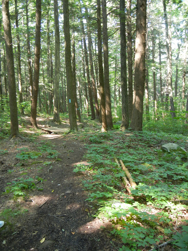
We had a small group on a day that was a little more humid than I was expecting.  We headed down into the woods with the kids in the lead.  (The kids are now timing us to see how long it takes us to catch up with them.  Hey, if that makes the trip more interesting for them and gives them a little something to bond over, then that's okay with me!  To my son I'll say, Just remember who is carrying the water.)

From the map in the Walk Book, we could see that this was a loop trail, but I must admit we had some trouble with that.

Heading in.  Blue blazes clearly marked.

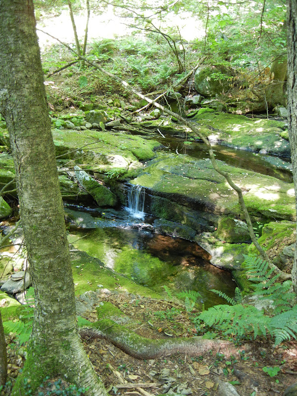
Pretty little stream.
Ferns, and I am not sure what the plant with the long, thin leaves is.


We kept following the trail down and along the stream until we came to the falls view point and this kind of funny sign.  Funny to me because it had an unofficial look to it.  Verboten Trail?  Really?

Is it:
Closed. No.        Anything Allowed. 

Or is it:
Closed.  No Anything Allowed.

I suspect it is the latter.

Alles erlaubt.  Nein!

Where the blue trail circles back at the top of the falls, it is supposed to connect to a white trail that leads to a better view of the falls down below.  The sign was telling us not to go there, I presume because of damage left from the October snowstorm.  I will admit I went a few steps down the trail just to see.  I also looked for white blazes without success.

Sure enough, trees across the trail.
So we went to the falls view point.  There was not much water flowing, but the moss covered rocks were pretty. 
Looking down over the falls to a pool below.

Moss covered rocks at the top of the falls.
So, we never made it to the bottom of the falls.  We also missed the return on the loop.  The funny sign seemed to indicate a crossing, and I think there may have been another sign that said something about a crossing without a bridge, but we got sidetracked.  We started back on a different blue trail, but very shortly came back to the trail we had been on on the way in.  My guess is that we were supposed to cross the stream, but we somehow missed that.

As we headed back towards the car, we saw where the loop came back in and a small bridge over the stream.  We had completely missed seeing this on the way in.

Small bridge near where the loop rejoins the trail in.


In the final stretch back to the car, we ran into some other people and I asked them if they knew where you were supposed to cross the stream to do the loop.  Apparently, they had done it only once before and had had the same problem.  Today, they were going to reverse direction and see if that made it easier to figure out where to cross.  Those had been my thoughts, too.  Next time, maybe in the fall when there aren't so many mosquitoes, I'll come back and try the loop in the other direction.

On the way home, we stopped at the overlook for the Barkhamsted Reservoir.  A nice view, but I bet it is really stunning in the fall.


Sunday, July 8, 2012

Avon/Simsbury - Farmington River Paddle

Date Paddled:  Sunday, July 8, 2012
Number in Group:  13
Estimated distance: 3.3 miles
Weather:  Sunny and warm, 85°F
Resources:  Farmington River Watershed Association, Huck Finn Adventures
Highlights of the trip: Wildlife, views, just enjoying the water

Although this was not a trip officially planned by the Farmington Valley Homeschool Hikers, most of the people who went on this trip do hike with us, so I thought I'd post about it.

From the Farmington River Watershed Association website (see above).


We started our paddle at Alsop Meadows in Avon (access point 22) and paddled to Route 185 and the giant Pinchot Sycamore Tree in Simsbury (access point 23).  Huck Finn Adventures has their base at Alsop Meadows and I appreciated that they were willing to help me get my kayak in the water even though I wasn't renting from them.  Others in the group did rent canoes and kayaks and were picked up at the Sycamore tree when they were done.

Starting out.  Route 44 bridge ahead.
Shortly after we started, we passed the Route 44 bridge.  We soon came to another small bridge decorated with flowers.  After seeing a golf cart pass overhead, it became apparent that we were passing Blue Fox Run. 

A little further on, on the western side of the river, we could hear gunfire.  The gunfire comes from the Nod Brook area noted in the Simsbury Walk Book.  This area is used for hunting dog training and field dog trials.

Mama and some ducklings.

Adult female and juvenile Common Mergansers.
Even for the middle of the day, we saw a fair amount of wildlife.  In addition to the ducks and mergansers noted above, we also saw a Green Heron, a Great Blue Heron, and quite a few fish.  We had a fisherman with us, and he caught a few.  Maybe he can tell us what kind they were.

B decided to swim part of the way.

A perfect day to be on, or in, the water.

Heublein Tower on the Metacomet Ridge.
We passed the Heublein Tower and could hear more gunfire, this time from the eastern side of the river.  We were passing the CT State Police firing range.  Eventually we came to the Route 185 bridge and our take out point at the Pinchot Sycamore tree.  There were quite a few people swimming in the water here and the parking lot was pretty full.  Someone had helped me shuttle my car here, so I loaded up.  Others had parked on Nod Road, just across the bridge (good to remember if the lot is full).  Huck Finn came and picked up the rest to take them back to their cars.  The entire trip, taken at a pretty leisurely pace, took about 2 hours.

This was a fabulous trip.  I think we should plan another one as part of our hiking group this fall.